Photos From Spaaaace
Views of the Earth from space are cool. Below I share how to take your own satellite selfie, and links to several live-ish photos of Earth from space!
But first, in case you missed it here’s my most recent video. In which I did something mildly naughty to make an 80’s pop culture reference.
EPIC
A few weeks ago I uploaded this video detailing how I made a digital photo frame that shows the most recent photos of Earth from NASA's DSCOVR:EPIC satellite camera.
In short:
- DSCOVR (Deep Space Climate Observatory) is a satellite between the Earth and the Sun.
- It has a camera called EPIC (Earth Polychromatic Imaging Camera).
- You can see EPIC’s photos online.
- I wrote some code to display EPIC’s photos with a Raspberry Pi.
- And seeing as many people asked, I was wearing Jo Franchetti’s No Worries If Not t-shirt, which is possibly my new favourite!
Several people have commented or tweeted asking if it would be possible to project these images onto a spehere to make a globe. While researching this topic, I found that Scott Manley had animated EPIC’s photos including mapping them onto a sphere. He also goes into detail about the different perspectives from the camera throughout the year, and from different points in the satellite’s orbit.
Other Satellites With Cameras
- NASA/USGS have been taking photos with satellites in the Landsat program since 1972. On LandsatLook Explore, you can view its photos of Earth from 1982 to the present day, and export timelapse footage comparing the differences over time
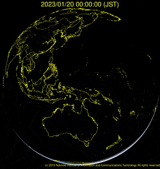
- Himawari-8 is a Japanese weather satellite in Geostationary orbit, with a view of Japan, East Asia, and the Western Pacific that takes photos every 10 minutes. You can see Himawari-8 photos in real time, or generate time lapse videos of a given day.
- NOAA’s GOES-East and GOES-West are geostationary satellites aligned with the east and west coasts of the USA respecitvely, and take full spectrum images of the Americas. The GOES Image Viewer lets you pick a region to see photos and animations
Downlinking Your Own Satellite Selfie
In 2015 I learned about the NOAA weather satellites orbiting the Earth, constantly transmitting what they can see below. They use a protocol called APT (Automatic Picture Transmission), and like a fax machine or scanner moving across paper, they send the image line-by-line as the satellite moves over the earth.
Thanks to the increases of computer power, and development of Software Defined Radio, you can downlink the images from these satellites as they pass overhead with nothing more than a laptop and an £8 TV tuner dongle!
I had a go at recieving weather satellite images in 2015 and documented the process. If I can find the energy, I might have a go at this again and capture it on video!

Links
As always, I’ll see you out with a few links to some completely unrelated things that I found interesting.
The Honda Electro Gyrocator is an amazing-looking pre-GPS in-car navigation system (Brianna Wu on mstdn.social)
A 10 minute tribute to 1215kHz AM. (Audioboom, via David Lloyd on Twitter)
Absolute Radio in the UK ceased broadcasting on 1215kHz AM, marking the first major switch-off of analogue radio broadcasting in the UK. David Lloyd recorded the 10 minute tribute that Absolute finished with.
Matt Amys shares some details of how Formula 1 broadcast live footage from cameras on the cars (YouTube)
Bex Ollerton (@Schnumn), is a comic artist who makes work about mental health, neurodivergence and the general struggles of being a human being in an overwhelming world. I really like her art style, and find most of them very relatable.
ha ha *screams*
— Bex Ollerton (@Schnumn) 12:39 PM ∙ Sep 12, 2022